 |
The System for
Convection Analysis
and Nowcasting (SCAN) |
|
SCAN 2.0
AWIPS 5.0 - Expected delivery to field in January/February 2001
RPS List Needs
The following WSR-88D Products must be included in the AWIPS RPS List of each dedicated radar in order to run the full suite of SCAN 2.0 functionality on each of those radars:
- Composite Reflectivity (CZ), 16-level, 1-km resolution, product #37 (Vital)
- Vertically Integrated Liquid (VIL), product #57 (Vital)
- Base Reflectivity (Z), 16-level, 1-km resolution, product #19 (Vital)
- Storm Track and Identification (STI), product #58 (Suggested)
- Mesocyclone (M), product #60 (Strongly suggested)
- Tornado Vortex Signature (TVS), product #61 (Strongly suggested)
Interpreting the SCTI values
The SCAN Convective Threat Index (SCTI) is a numerical representation
of the severe weather occurring within a CWA. The SCTI button is located
directly below the WarnGen button on the D2D. The SCTI button has a severe
weather symbol on it. The button will be colored according to the following
criteria:
| White | Little or no activity in the CWA |
| Green | General thunderstorms with low severe weather probabilities in the CWA |
| Yellow | Thunderstorms with moderate severe weather probabilities or a mesocyclone or TVS detected in the CWA |
| Red | Thunderstorms with high severe weather probabilities and a mesocyclone and/or TVS detected in the CWA |
| Grey | Invalid index number, which means the SCAN processor is not behaving properly. |
If the mouse cursor is focused over this colored button, a small text
tip widget will appear, providing the maximum SCTI valueover the CWA and
what it represents. In addition to the SCTI button, the actual grid of
SCTI values over the CWA can be viewed via a D2D depictable, selectable
from the SCAN section of the radar menus. The following table can be used
to interpret the SCTI values:
| 100 | Cell SWP >=70, MESO & TVS |
| 90 | Cell SWP >=70, MESO or TVS |
| 80 | Cell SWP >=70 |
| 70 | 30 <= Cell SWP < 70, MESO & TVS |
| 60 | 30 <= Cell SWP < 70, MESO or TVS |
| 50 | 30 <= Cell SWP < 70 |
| 40 | Cell SWP < 30, MESO & TVS |
| 30 | Cell SWP < 30, MESO or TVS |
| 10 | CG LTG, High VIL, CZ |
To make the SCTI values, we see which of the following "ingredients" are
present in a radar-centric field of 4x4 km grid boxes - VIL, 4-km CZ,
NLDN lightning, TVSs, MESOs, and our cell-based Severe Weather Probabilities
(SWPs). The non-gridded data - lightning, MESOs, TVSs, and SWPs - are
assigned to the nearest grid box. Depending on how many severe weather
indicators are present in each grid box (and in what combinations), the
box is assigned a SCTI value. It is important to keep in mind that these
numbers are not percentages; they are assigned threat values that model
the gamut between a garden variety thunderstorm and a rotating, tornadic
supercell. The numbers are not cumulative -- a grid box with CG lightning
and high VIL (for
a SCTI value of 10) that also has a MESO, TVS, and high SWP (a SCTI value
of 100) will not be assigned a a value of 110; instead, the maximum threat
found is the one that is used.
See the SCAN 2.0 User's Guide
for information on the SCTI.
![]()
Editing the SCAN Site List and Use of Spotter Maps
Below are instructions on how to edit the site list for the SCAN thunderstorm
site detection function in AWIPS 4.1, i.e., the function that monitors
for the presence of a thunderstorm threat at a fixed geographic (point)
location. It might be useful to add the locations of fixed spotters to
this list in order to automatically monitor for the occurrence of thunderstorms
at these locations. The spotter map depictable could be used in conjunction
with the SCAN site threat depictable. This information is also being included
in the 4.2 D2D User's Guide.
To add a local site of interest (such as a local landmark or a spotter
location, for example) to the SCAN site field, perform the
following steps:
- If the SCAN site threat depictable is loaded in the IGC screen, unload the depictable.
- Use an editor to open the file: /data/fxa/radar/XXXX/tstorm/sites.dat, where "XXXX" is the
- four-letter identifier of the dedicated radar.
- At the bottom of the file add a new line. At the beginning of the line, type a character string
- (with a maximum size of 5 characters) as an identifier. Note that any new sites should be
- placed at the bottom of the file -- not in alphabetical order in the list -- so as not to disrupt
- the site ordering of previous SCAN runs in the inventory.
- Skip at least 1 space and, on the same line as the identifier, add the latitude of the new site
- in decimal degrees format.
- Skip at least 1 space and , on the same line as the identifier and latitude, add the longitude
- of the new site in decimal degrees format, using a negative value to represent a point
- west of the prime meridian.
- Save the file.
- To test the addition, wait at least 1 volume scan before displaying the SCAN site
- threat depictable. When the depictable is loaded, the new site should be displayed
- in the site field. If the site threat popup window is invoked, the text message inside
- will describe the conditions at the site.
Sites can also be removed from the "sites.dat" file by deleting the appropriate
line of site information. The file should contain no blank lines. Note
that this action may cause site threat data mismatches in the previously
inventoried site threat message files. It is therefore recommended that
this action only be taken in fair-weather conditions, when the inventoried
files are less likely to be displayed.
![]()
Using the "purgetime.txt" file
The editable "purgetime.txt" file in the $FXA_DATA/tstorm directory allows the user to change the number of hours beyond which the purge function will delete records in the SCAN Storm Cell database tables. For example, if the file contains "5.0", when the purge function is called, it would delete all records older than 5.0 hours for all tables (cells, mesos, tvs's, and sites) in the "scandata" database.
Click on the link below to bring up a new window with the latest version
of the SCAN User's Guide.
SCAN 2.0 User's Guide
![]()
SCAN 2.0 Screen Captures
Click on an image to see the full size image:|
|
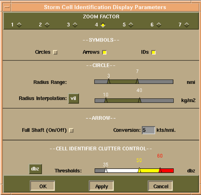 The Storm Cell Identification Display (SCID) window. |
|
|
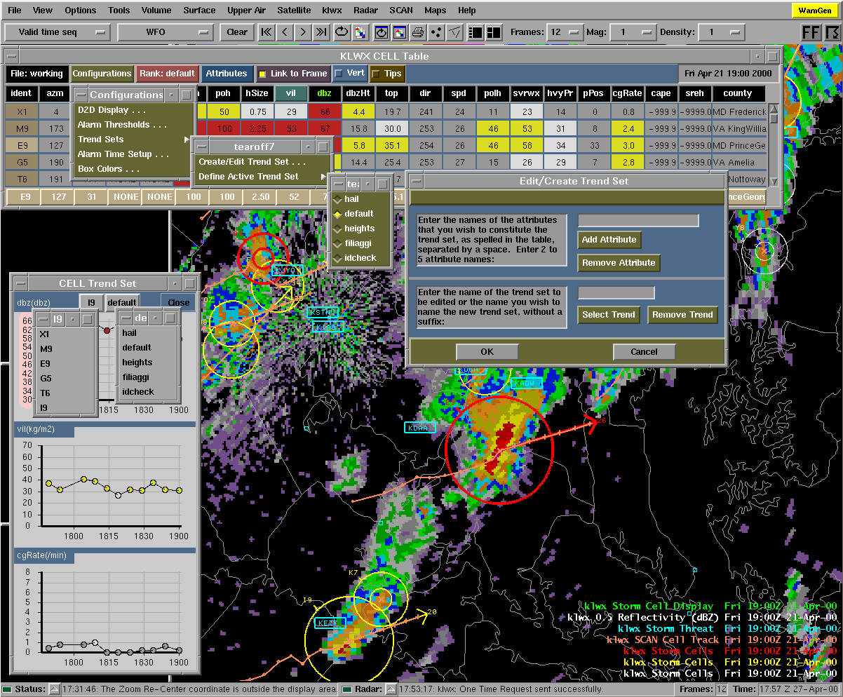
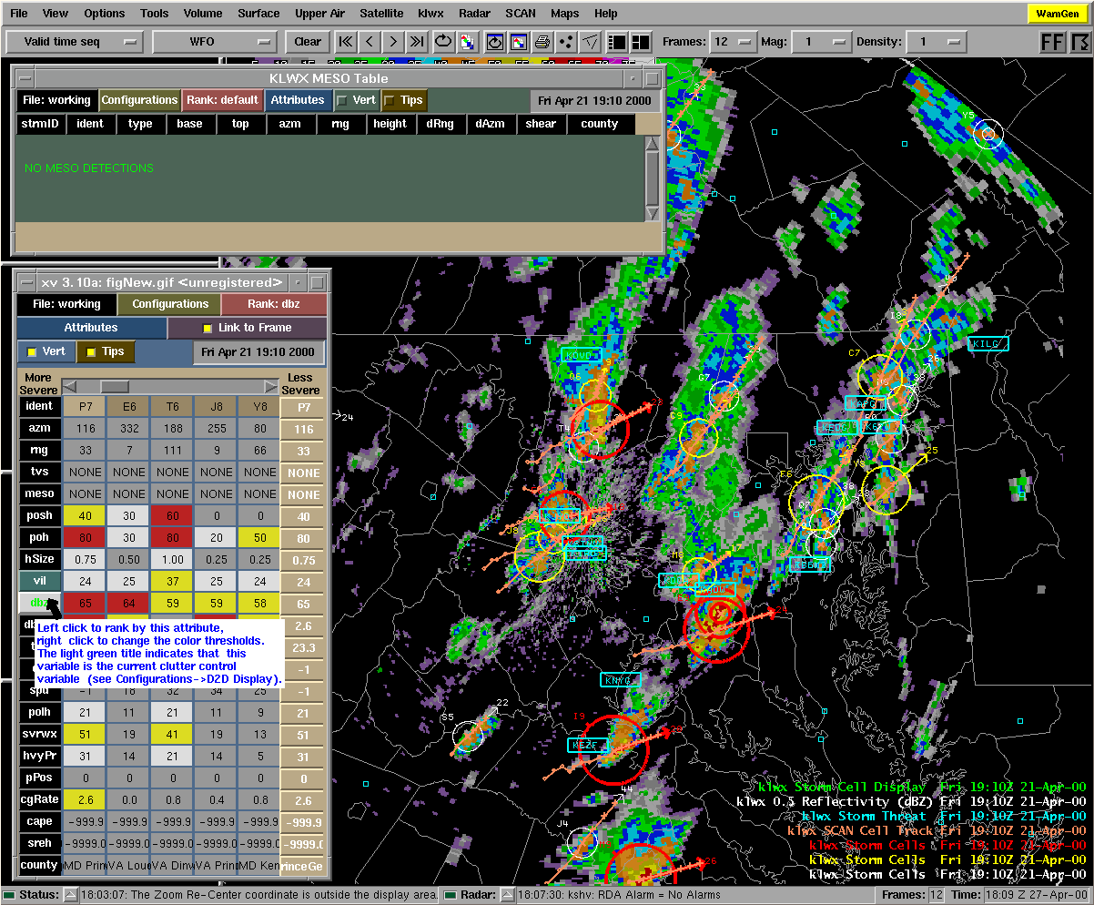
 SCAN Data Monitoring System |
|
|
|

Home
|
National
Weather Service |