1. INTRODUCTION
The Meteorological Development Laboratory (MDL) of the National Weather Service (NWS) has developed regression equations to predict the probabilities of seven categories of ceiling height and four categories of total sky cover. The equations were developed by applying the Model Output Statistics (MOS) technique (Glahn and Lowry 1972) to output from the Aviation (AVN) run of the National Center of Environmental Prediction's (NCEP) Global Spectral Model (GSM; Kanamitsu 1989). In addition to the probability forecasts, categorical forecasts are produced by using a selection scheme designed to predict as many events of each category to occur as were observed. AVN MOS ceiling height and total sky cover forecasts are now being generated for projections of 6 to 72 hours at 3-h intervals after 0000 and 1200 Universal Coordinated Time (UTC). The ceiling height and total sky cover equations are closely associated due to their simultaneous development (see Section 2f); therefore, both the ceiling height and total sky cover guidance are described in this bulletin.
2. DEVELOPMENT AND DEFINITIONS
a. Method
The MOS approach correlates predictand data (local weather observations) with combinations of predictor data (output from dynamical models, surface observations, and geoclimatic information). In applying MOS to the prediction of ceiling height and total sky cover, both elements were treated as categorical predictands. In other words, the range of ceiling height and total sky cover was divided into mutually exclusive and collectively exhaustive categories. Both the ceiling height predictand and the total sky cover predictand were then set equal to 1 for the observation occurring within each element's respective category and to 0, otherwise. The number of predictands representing each element corresponds to the number of ceiling height or total sky cover categories, respectively. A multiple linear regression (forward) screening procedure was then used to derive the prediction equations. Operationally, the equations produce probability forecasts of the various categories. A categorical forecast is then determined from the probabilities (see Section 2h).
b. Seasons
Developmental data from April 1997 through March 2000 were stratified into two, 6-month seasons: cool (October-March) and warm (April-September). Three seasons of data (approximately 600 days) were used to develop both the warm season and cool season equations. When feasible, data covering approximately 2 weeks of seasonal overlap on either side of each season were added to smooth the transition between warm and cool season equations.
c. Predictands
Since ceiling height has an irregular frequency distribution, the predictand was divided into the seven categories shown in Table 1a. The category definitions are the same as those used for the Nested Grid Model (NGM) MOS ceiling height forecasts (Miller 1995). AVN MOS ceiling height categories 1 and 2 match the aviation ceiling height definition for Limited Instrument Flight Rules (LIFR), category 3 matches the definition for Instrument Flight Rules (IFR), and category 4 matches the definition for Marginal Visual Flight Rules (MVFR). Category 5 ends at 6500 ft, approximating the cutoff between low and middle cloud reports. Category 6 ends at 12000 ft, reflecting the limits of Automated Surface Observing System (ASOS) reports. Categories 5, 6, and 7 correspond to the ceiling height definition for Visual Flight Rules (VFR). Table 2 summarizes the LIFR, IFR, MVFR, and VFR ceiling height definitions.
Total sky cover is divided into four categories as shown in Table 1b. Clear indicates zero cloud coverage. Scattered corresponds to cloud coverage greater than zero and up through 4/8. Broken indicates cloud coverage greater than 4/8 and less than 8/8. Overcast corresponds to 8/8 cloud coverage, and also includes totally obscured sky cover. The range limits of the NGM and AVN MOS categorical definitions for total sky cover are the same, but the cloud estimates used for the NGM MOS sky cover forecasts are different. The AVN MOS predictand represents the measurement of total sky cover, whereas the NGM MOS predictand represented the measurement of cloud cover from clouds defined as opaque.
The methods used to estimate the ceiling height and cloud cover predictand values have changed since the NGM MOS was developed in 1993. Measurements from manual reporting sites made up most of the predictand values used to develop the NGM MOS whereas measurements from ASOS reporting sites make up the majority of AVN MOS predictand ceiling height and total sky cover values. The chief consideration with ASOS reports is the inability to detect clouds above 12000 ft. The ceiling height predictand is unaffected by this limitation since the maximum categorical limit is 12000 ft. The total sky cover predictand has no height limit; therefore, the ASOS total sky cover estimates are complemented with Satellite Cloud Product (SCP) estimated cloud coverage to obtain cloud information above 12000 ft (Kluepfel et al. 1994).
MDL archives the hourly surface observations of cloud cover and cloud height, and hourly SCP reports for all available stations in the contiguous United States (CONUS), Alaska, Hawaii, and Puerto Rico. From these reports, the ceiling height and total sky cover were estimated. A total of 1060 stations were included in the AVN MOS forecast system. Of these stations, 765 were used to develop the MOS equations. We estimated ceiling height and total sky cover every 3 hours from 0000 to 2100 UTC. The observations valid at 0000, 0300, ..., 2100 UTC provided the predictand data sample. These observations were used to generate predictand quantities valid every 3 hours from 6 through 72 hours after either 0000 or 1200 UTC.
d. Predictors
Potential predictors included AVN model forecasts, geoclimatic variables, and surface weather observations. The AVN model predictors consisted of relative humidity variables, wind components, wind speed, vertical velocity, relative vorticity, absolute vorticity advection, the lifted condensation level, relative humidity times vertical velocity, total precipitable water, 3-h precipitation amount, and the K Index. Table 3a indicates the levels at which these variables were valid. The model predictors were available at 3-h intervals for the 6-h through 72-h forecasts following either 0000 or 1200 UTC. Thus, for every predictand projection, corresponding model predictors were available. For example, predictors valid at 12 hours after 0000 or 1200 UTC were used for the 12-h MOS forecast equations. All of the AVN model predictors were space smoothed over 25 model gridpoints for all projections. This spatial smoothing reduces some of the small-scale variability found in model forecasts that is not useful for ceiling height or total sky cover prediction.
The geoclimatic predictors, listed in Table 3b, included the first and second harmonics of the day of the year, the monthly relative frequency of ceiling height below 1000 ft, and the monthly relative frequency of total sky cover for clear, scattered-broken combined, and overcast. These predictors attempt to account for seasonal variations in ceiling height and total sky cover not accounted for by other predictors. The monthly relative frequencies were compiled over the same period (April 1997 through March 2000) used for equation development, and included the same 765 stations mentioned in Section 2c. Latitude, longitude, and surface elevation were also included as predictors. These predictors attempt to explain geographic variations within a given region (see Section 2e).
Surface weather observations were included as potential predictors for the 6-h through 18-h forecast equations as a means of incorporating persistence into the regression equations. These predictors, also shown in Table 3b, included the observed ceiling height, non-SCP complemented total sky cover, wind speed, and wind direction, all reported 3 hours after 0000 or 1200 UTC. We used observations valid at 0300 UTC and 1500 UTC because they are usually available when the AVN MOS program is run operationally.
While many of the potential predictors were continuous variables, others were either point-binary or grid-binary variables (Jensenius 1992) as indicated in Table 3. The point-binary technique applies the binary cutoff to the predictor valid at a specific station. The resulting value of the predictor is either 0 or 1. The observed ceiling height and total sky cover are point-binary predictors as shown in Table 3b. The grid-binary technique applies the binary cutoff at gridpoints, then the gridded field of 1's and 0's is smoothed and interpolated to stations. The resulting predictor values also range between 0 and 1. This technique provides a smoother transition, both spatially and temporally, between the extremes of the predictor than does the point-binary approach.
e. Regions
To enhance our ability to predict the occurrence of relatively infrequent events and develop more stable forecast relationships, we combined stations into geographic regions. In this regional equation approach, the predictand and predictor data from several stations within a similar geographical or climatic area are pooled, and one set of equations is derived for the region.
To construct the regional boundaries used for this development, we started with the regional boundaries used for the NGM MOS development of cloud amount. The NGM MOS boundaries were established by grouping stations with similar frequencies of cloud occurrence and then adjusting the boundaries to similarities in predictor selection and geography. We assumed these boundary conditions to be unchanged, and proceeded to adjust these regional boundaries to best fit the AVN MOS development. First, we compared the probability forecasts of the NGM MOS and AVN MOS "test" equations for one warm/cool season (see section 3). For each region, the P-score (mean square error of a probabilistic forecast) was compared for selected projections. Based on this comparison, the regional boundaries were modified by grouping stations where P-score improvement of AVN MOS over the NGM MOS was maximized and geographical integrity maintained. The boundaries for the regions used in the NGM MOS ceiling height guidance system were also used to help finalize the AVN MOS regional boundaries. After completing the adjustments, we established 22 warm season and 21 cool season CONUS regions shown in Figs. 1a and 1b. Seven Alaska regions were used for both warm and cool seasons, and are shown in Fig. 1c. One region each was designated for Hawaii and Puerto Rico.
f. Equation Development
Equations were developed for the 6-h, 9-h, 12-h, ..., 69-h, and 72-h projections after 0000 and 1200 UTC. Two sets of equations were derived for the 6-h through 18-h projections. In the first (primary) set, surface weather observations at 0300 or 1500 UTC, AVN model forecasts, and geoclimatic variables were included as predictors. In the second (secondary) set, we used only AVN model forecasts and geoclimatic variables as predictors. In operations, the primary equations are used whenever possible to generate the forecast. However, when the observations are unavailable as predictors in a particular equation, the secondary equation is used.
The probability equations for the seven ceiling height and four total sky cover categories were developed simultaneously for each projection. The resulting forecast equations for all ceiling height and total sky cover categories contain the same predictors, although the regression coefficients and constants vary among the predictands. The equations for these predictands were developed simultaneously to enhance consistency among the forecasts generated by the equations.
During equation development, we allowed the regression process to continue until a maximum of 18 predictors was chosen or until none of the remaining predictors contributed an additional 0.5% to the reduction of variance averaged over all eleven predictands. For most regions and projections, 18 predictors were chosen. In the 6-h through 12-h projections (primary equations), the observed ceiling height and total sky cover were among the top predictors; by the 18-h projection, this was no longer the case. At later projections, the 1000 - 440 hPa and 850 - 700 hPa mean relative humidity, the 850-hPa relative humidity multiplied by the vertical velocity, the precipitable water, the U and V wind components for levels below 500 hPa, and the relative frequencies of both ceiling height and total sky cover contributed most of the reduction of variance. Additional frequently selected predictors included the K-Index, the 3-h total precipitation, the vertical velocity variables for levels below 300 hPa, and the 1000-hPa wind speed.
g. Normalization
The technique of simultaneous development ensures that the resulting probabilities for a given case of either ceiling height or total sky cover sum to 100%, although individual category forecasts greater than 100% or less than 0% are possible. To eliminate these latter probabilities, we post-process the raw forecasts. All raw probabilities less than 0% are set to 0%, then each probability is divided by the sum of the positive probabilities to obtain normalized values. The resulting probabilities add to 100%, and the individual category forecasts do not exceed 100% or fall below 0%.
h. Transformation of Probability Forecasts to Categorical Forecasts
In daily operations, we make a categorical forecast based on the probability forecasts produced by the equations. In our processing, when the forecast probability of a given category exceeds a certain critical value (probability threshold), that category is chosen to be the categorical forecast. For example, in the case of ceiling height, the procedure starts by comparing the forecast probability of the rarest event (ceiling height < 200 ft), to the probability threshold of this category. If the forecast probability exceeds the probability threshold, then this category is selected as the categorical forecast. If the forecast probability for this category does not exceed the probability threshold, then the forecast probability for ceiling height 200 - 400 ft is added to the forecast probability of ceiling height < 200 ft to obtain the cumulative probability. The cumulative probability is then compared to the probability threshold for the two categories combined. If the cumulative forecast probability exceeds this probability threshold, then the category for ceiling height 200 - 400 ft is selected as the categorical forecast. If the cumulative forecast probability does not exceed the probability threshold, then the process continues in this stepwise manner through the first six categories. If the probability thresholds are never exceeded for the first six categories, then category 7, the most common event, is selected as the default categorical forecast. Categorical forecasts for total sky cover are determined the same way by processing from clear to overcast.
Probability thresholds are required for ceiling height categories 1 to 6 and for the total sky cover categories of clear, scattered, and broken. Thresholds are unnecessary for ceiling height > 12000 ft, and for overcast sky cover since these are the default categories. Probability thresholds must be available for each region, projection, cycle, and season, and for both primary and secondary equations. The probability thresholds are obtained from the developmental sample by using an iterative process based on a user-specified bias of 1.0, that is, the number of forecasts and observations is approximately equal.
I. Sample Equation
Sample regression equations to predict the probability of the ceiling height and total sky cover categories for region 20 (Fig. 1b) are included in Tables 4a, 4b and 4c. The equations listed, primary equations in this case, are used in the cool season to generate probability forecasts valid 12 hours after 0000 UTC. The predictors are listed in Table 4a in the order they were selected by the regression procedure. The column labeled TYPE indicates whether the predictor is a continuous (C), a point binary (PB), or a grid binary (GB) variable. The cutoffs for point-binary and grid-binary predictors are indicated in the predictor description. The TAU column indicates the projection of the predictors in hours after the forecast cycle. The regression constant and predictor coefficients of the seven ceiling height equations and the four total sky cover equations are shown in Tables 4b and 4c, respectively. As mentioned in section 2.f, the predictors of all eleven ceiling height and total sky cover amount equations are the same, but the coefficients and constants differ. The probability threshold values for ceiling height and total sky cover are listed in Tables 5a and 5b, respectively.
Remember, although it is useful to know which predictors are contained in the forecast equations, interpretation of individual coefficients in a multiple linear regression equation is generally not recommended. These coefficients reflect not only the relationship of the predictand to the given predictor, but also the relationship of the given predictor to other predictors in the equation. Since in most instances, the predictors included in the equation are correlated with one another, discussion of the effect of changing one predictor within a given forecast equation without considering related variables may not be of much value.
3. VERIFICATION OF CATEGORICAL CEILING HEIGHT AND TOTAL SKY COVER FORECASTS
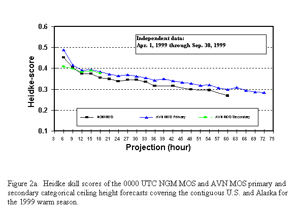
Prior to implementation of the AVN MOS categorical ceiling height/total sky cover forecast system, we developed a set of test equations based on two warm seasons (April-September) and two cool seasons (October-March) of dependent data. We then verified forecasts from these equations on a season of independent data, and compared the results to the operational NGM MOS categorical ceiling height and cloud amount forecasts. As mentioned in section 2.c, the categorical definitions used for the AVN and NGM MOS ceiling height forecasts are identical, and those used for the cloud coverage forecasts are similar. In general, the AVN MOS forecasts were more skillful than the NGM MOS forecasts. For ceiling height (Figs. 2a and 2b) and total sky cover (Figs. 3a and 3b), the Heidke skill scores (Dagostaro 1985) are shown for the 0000 UTC test AVN MOS and the operational NGM MOS guidance for the 1999 warm season and the 1999-2000 cool season, respectively. The Heidke skill score eliminates the influence of forecasts that would have been correct by chance. Higher Heidke skill scores indicate greater skill. For both ceiling height and total sky cover, the AVN MOS forecasts were more skillful at every 3-h projection over both seasons. The larger difference in skill observed for total sky cover may be attributed to different predictand quantities used to develop the NGM MOS equations (see section 2.c). We also compared the threat scores for ceiling height categories 1 and 2 for both the NGM and AVN MOS. The threat score measures the ability of the forecasts to identify correctly the threat event (in this case, ceiling heights of less than 500 ft). Figs. 4a and b show the AVN MOS threat scores to be almost always greater than the NGM MOS guidance.
Though results are shown only for the 0000 UTC forecasts, results of the 1200 UTC forecasts were found to be consistent with the 0000 UTC results. Additional results which include both the 1200 UTC comparisons as well as regional comparisons for the 0000 and 1200 UTC forecast cycles can be found on the Internet at the following address: http://www.nws.noaa.gov/tdl/synop/
4. THE ALPHANUMERIC MESSAGE
The AVN MOS ceiling height and total sky cover forecasts are available in the new AVN MOS forecast bulletins, which are distributed in 10 alphanumeric messages. The listing of the WMO headers along with a complete description of the AVN MOS message can be found in Technical Procedures Bulletin No. 463 (Dallavalle and Erickson 2000). The AVN MOS forecasts can be accessed as a text message on AWIPS. In the forecast bulletin, categorical ceiling height and total sky cover forecasts are available every 3 hours for the 6-h through 60-h projection and then every 6 hours through the 72-h projection. A sample of the ceiling height and total sky cover portion of the bulletin is shown in Fig. 5, where the categorical total sky cover forecasts are available on the line labeled CLD, and the categorical ceiling height forecasts are available on the line labeled CIG. Total sky cover forecasts are displayed with the notations CL, SC, BK, and OV which correspond to the total sky cover categories defined in Table 1b. Ceiling height forecast are displayed by the number range of one through seven which correspond to the ceiling height categories defined in Table 1a. The probabilistic and categorical forecasts are also available valid every 3 hours for the 6-h through 72-h projections in a binary format (BUFR) message. For users outside the National Weather Service, the new guidance is available through NOAAPORT, the Family of Services, and specific military communications circuits. The AVN MOS forecast message is produced for 1060 sites in the CONUS, Alaska, Hawaii, and Puerto Rico. The ceiling height and total sky cover forecasts are available for all stations every day of the year.
5. OPERATIONAL CONSIDERATIONS
The MOS categorical forecasts for ceiling height and total sky cover are based on the AVN model output. As one would expect when using a statistical technique like MOS, forecast accuracy is only as good as the information supplied by the forecast model. The multiple linear regression technique can account for some systematic biases in the AVN model, but regression cannot correct bad model forecasts.
Although the AVN MOS categorical ceiling height and total sky cover forecasts are generally more skillful than the NGM MOS forecasts, rare events like low ceiling heights still pose problems for the AVN-based MOS system. Under forecasting of low level clouds and ceiling height caused by low level upslope along the east slope of the Rockies has been observed. High false alarm rates of early morning low level fog for stations over the eastern U.S. has also been observed.
For stations that reliably report hourly conditions, 0300 and 1500 UTC observation contributed significantly to the skill of the AVN MOS categorical ceiling height and total sky cover forecasts at the 6-, 9-, and 12-h projections. The dependence of these predictors on forecast skill decreased rapidly by the 18-h projection. This indicates the importance of persistence during the first 12 hours after the model cycle time. Persistence contributed slightly more skill to the ceiling height forecasts than to the total sky cover guidance.
As discussed in section 2f, the ceiling height and total sky cover guidance were developed simultaneously. In general, the categorical forecasts of the two are consistent with one another. There are, however, cases where inconsistency occurs. The causes may either be meteorological, observation-related, or both. For instance, broken or overcast sky cover can be forecast with ceiling height forecasts of category 7 (ceiling height above 12000 ft). In this case, it is uncertain whether a category 7 designation represents a forecast of ceiling height above 12000 ft or clear skies (unlimited ceiling). The case of a clear or scattered total sky cover forecast combined with a ceiling height forecast of 6 or lower always indicates a meteorological forecast inconsistency.
As a final note, some regions will not have forecasts for ceiling height categories 1 and/or 2 at certain projections. In these cases, observations of these categories were so rare that the 3-year developmental data sets did not contain enough cases to develop an equation. This was particularly true over the regions covering the southwest CONUS during the warm season and for both Hawaii and Puerto Rico for all projections during the warm and cool seasons.
6. REFERENCES
Dagostoro, V. J., 1985: The National AFOS-era verification data processing system. TDL Office Note 85-9, National Weather Service, NOAA, U.S. Department of Commerce, 47 pp.
Dallavalle, J. P., and M. C. Erickson, 2000: AVN-based MOS guidance - The alphanumeric messages. NWS Technical Procedures Bulletin No. 463, National Oceanic and Atmospheric Administration, U.S. Department of Commerce, 10 pp.
Glahn, H. R., and D. A. Lowry, 1972: The use of Model Output Statistics (MOS) in objective weather forecasting. J. Appl. Meteor., 11, 1203-1211.
Jensenius, J. S., Jr., 1992: The use of grid-binary variables as predictors for statistical weather forecasting. Preprints Twelfth Conference on Probability and Statistics in the Atmospheric Sciences, Toronto, Amer. Meteor. Soc., 225-230.
Kanamitsu, M., 1989: Description of the NMC global data assimilation and forecast system. Wea. and Forecasting, 4, 335-342.
Kluepfel, C. K., A. J. Schreiner, and D. A. Unger, 1994: The satellite-derived cloud cover product (sounder). NWS Technical Procedures Bulletin No. 410, National Oceanic and Atmospheric Administration, U.S. Department of Commerce, 15 pp.
Miller, D. T. 1995: NGM-based MOS ceiling height guidance for the contiguous United States. NWS Technical Procedures Bulletin No. 414, National Oceanic and Atmospheric Administration, U.S. Department of Commerce, 14 pp.
Table 1a. AVN MOS ceiling height categories.
| Category | Height above the surface |
| 1 | < 200 ft |
| 2 | 200 - 400 ft |
| 3 | 500 - 900 ft |
| 4 | 1000 - 3000 ft |
| 5 | 3100 - 6500 ft |
| 6 | 6600 - 12000 ft |
| 7 | > 12000 ft |
Table 1b. AVN MOS total sky cover categories.
| Category | Cloud coverage |
| Clear (CL) | zero |
| Scattered (SC) | > zero - 4/8 |
| Broken (BK) | > 4/8 - < 8/8 |
| Overcast (OV) | 8/8 |
Table 2. Aviation ceiling height categories
| Aviation Condition | Height above the surface |
| LIFR | < 500 ft |
| IFR | 500 - 900 ft |
| MVFR | 1000 - 3000 ft |
| VFR | > 3000 ft |
Table 3a. Potential AVN model predictors used for ceiling height and total sky cover equation development.
| Parameter | Level | Predictor Type |
| Mean Layer Relative Humidity | 1000 - 970 hPa, 1000 - 925 hPa
1000 - 850 hPa, 1000 - 440 hPa 925 - 850 hPa, 925 - 700 hPa 850 - 700 hPa, 700 - 500 hPa |
Continuous/Grid Binary
(30, 50, 70, and 85 % grid binary cutoffs) |
| Relative Humidity
|
1000 hPa, 925 hPa, 850 hPa,
700 hPa, 500 hPa |
Continuous/Grid Binary
(30, 50, 70, and 85 % grid binary cutoffs) |
| U Wind Component | 1000 hPa, 925 hPa, 850 hPa,
700 hPa, 500 hPa, 300 hPa |
Continuous |
| V Wind Component | 1000 hPa, 925 hPa, 850 hPa,
700 hPa, 500 hPa, 300 hPa |
Continuous |
| Wind Speed | 1000 hPa, 925 hPa, 850 hPa,
700 hPa, 500 hPa, 300 hPa |
Continuous |
| Vertical Velocity | 850 hPa, 300 hPa | Continuous |
| Vertical Velocity | 700 hPa, 500 hPa | Continuous/Grid Binary
(-0.2, -0.1, 0.0, 0.1 Pa/s cutoffs) |
| Relative Vorticity | 850 hPa, 700 hPa, 500 hPa,
300 hPa |
Continuous |
| Absolute Vorticity Advection | 850 hPa, 700 hPa, 500 hPa,
300 hPa |
Continuous |
| Vertical Velocity * Mean Relative Humidity | 850 hPa, 700 hPa, 500 hPa | Continuous |
| Lifted Condensation Level | 1000 hPa, 925 hPa | Continuous |
| 3-H Precipitation Amount | - | Grid Binary (0.254, 2.54, 6.35 mm cutoffs) |
| Total Precipitable Water | - | Continuous |
| K Index | - | Continuous |
Table 3b. Potential geoclimatic and observation predictors used for ceiling height and total sky cover equation development. Observations are only used as predictors for the 6-h through the 18-h projections.
| Parameter | Predictor Type |
| Latitude | Continuous |
| Longitude | Continuous |
| Sine and Cosine (day of year) | Continuous |
| Sine and Cosine (2 * day of year) | Continuous |
| Relative Frequency of Ceiling Height < 1000 ft | Continuous |
| Relative Frequency of (Clear) | Continuous |
| Relative Frequency of (Scattered/Broken) | Continuous |
| Relative Frequency of (Overcast) | Continuous |
| Station Elevation | Point Binary (100, 500, 1000, 2500, 5000 ft cutoffs) |
| Observed Ceiling Height | Point Binary (100, 200, 500, 1000, 3100, 6600, 12100 ft cutoffs) |
| Observed Total Sky Cover (un-complemented) | Point Binary (scattered, broken, overcast cutoffs) |
| Observed Surface Wind Speed | Continuous |
| Observed Surface U Wind Component | Continuous |
| Observed Surface V Wind Component | Continuous |
Table 4a. Predictors used to compute the probability forecasts of the seven ceiling height and four total sky cover categories for cool season (October-March) region 20 (Fig. 1b). The values of these predictors are used to generate forecasts valid 12 hours after 0000 UTC. Predictors with no units indicate values between 0 and 1.
| TERM | PREDICTOR NAME | TYPE | UNITS | TAU |
| 1
2 3 4 5 6 7 8 9 10 11 12 13 14 15 16 17 18 |
1000 - 440 hPa Mean Rel. Humidity
1000 - 850 hPa Mean Rel. Humidity (85% cutoff) Total Cloud Amt. Rel. Frequency (Scattered/Broken) Observed Ceiling Height (> 1000 ft) 1000 hPa U - Wind Component 1000 - 440 hPa Mean Rel. Humidity (85% cutoff) 700 - 500 hPa Mean Rel. Humidity (70% cutoff) 500 hPa Vertical Velocity (0.1 cutoff) 500 hPa Mean Rel. Humidity (30% cutoff) 1000 - 850 hPa Mean Rel. Humidity (70% cutoff) Observed Ceiling Ht. (> 500 ft) Observed Surface Total Cloud Amt. (Clear) Observed Ceiling Ht. (> 3100 ft) 1000 hPa V - Wind Component 1000 - 970 hPa Mean Rel. Humidity (85% cutoff) Total Cloud Amt. Rel. Frequency (Clear) Observed Ceiling Ht. (> 6600 ft) 850 hPa Rel. Humidity * Vert. Velocity |
C
GB C PB C GB GB GB GB GB PB PB PB C GB C PB C |
%
- - - m/s - - - - - - - - m/s - - - % - Pa/s |
12
12 12 3 12 12 12 12 12 12 3 3 3 12 12 12 12 12 |
Table 4b. The regression constants and 18 predictor coefficients for the regression equations used to compute the probability forecasts of the seven ceiling height categories for cool season (October-March) region 20 (Fig.1b). The predictor coefficients correspond to the 18 predictors as they are listed in Table 4a. The equations are used to generate forecasts valid 12 hours after 0000 UTC.
| TERM | 1 | 2 | 3 | 4 | 5 | 6 | 7 |
| CONSTANT
1 2 3 4 5 6 7 8 9 10 11 12 13 14 15 16 17 18 |
.263E+00
.332E-03 -.770E-01 -.965E-01 -.365E-01 -.337E-02 -.108E-01 -.366E-01 -.192E-01 -.188E-01 .232E-01 -.140E+00 .351E-02 -.152E-01 .373E-02 .591E-01 -.480E-01 -.755E-02 .490E-03 |
.198E+00
.553E-03 .394E-01 -.236E-01 -.691E-01 -.202E-02 .126E-01 -.394E-01 .752E-02 -.194E-01 -.446E-01 -.105E+00 .457E-02 -.138E-01 .190E-02 .881E-01 .960E-02 -.847E-02 -.115E-02 |
.820E-02
.439E-03 .852E-01 .274E-01 -.108E+00 -.735E-03 .112E+00 -.591E-01 .499E-02 -.637E-02 -.393E-01 .108E+00 .206E-02 -.290E-01 -.156E-02 .707E-01 .292E-01 -.852E-02 -.205E-02 |
-.113E+00
.206E-03 .223E+00 .929E-01 .121E+00 -.362E-02 .157E-01 .538E-01 -.855E-02 .962E-02 -.673E-02 .681E-01 -.156E-02 -.110E+00 -.154E-02 .277E-01 .650E-01 -.146E-01 -.635E-03 |
.527E-01
-.552E-03 .126E+00 -.174E+00 .671E-01 -.536E-02 -.192E+00 .167E+00 -.827E-02 .193E-01 .261E+00 .254E-01 .103E-01 .872E-01 -.274E-02 -.177E+00 -.273E+00 -.834E-01 .131E-02 |
-.137E+00
.395E-02 -.166E-02 .194E-02 -.898E-02 -.363E-03 -.585E+00 .467E+00 -.458E-01 -.157E-01 -.148E-01 .178E-01 .345R-01 .314E-01 .195E-02 -.714E-01 -.101E+00 .340E-01 .118E-02 |
.729E+00
-.493E-02 -.395E+00 .172E+00 .340E-01 .155E-01 .647E+00 -.552E+00 .694E-01 .506E-01 -.178E+00 .252E-01 -.534E-01 .494E-01 -.174E-02 .284E-02 .318E+00 .886E-01 .850E-03 |
Table 4c. Same as Table 4b, but for the four total sky cover categories.
| TERM | CLEAR | SCATTERED | BROKEN | OVERCAST |
| CONSTANT
1 2 3 4 5 6 7 8 9 10 11 12 13 14 15 16 17 18 |
.315E+00
-.132E-02 -.999E-01 -.151E+00 .105E-01 .634E-02 .374E+00 -.928E-01 .258E+00 -.206E+00 -.164E+00 .270E-02 -.106E+00 .338E-01 -.106E-02 .107E-01 .688E+00 .239E-02 -.324E-03 |
.186E+00
-.204E-02 -.174E+00 .440E+00 .124E-01 .839E-02 .365E+00 -.381E+00 -.119E-01 .333E-01 .600E-01 .479E-02 .112E-01 .249E-01 -.400E-02 -.793E-01 -.226E+00 .452E-01 .679E-03 |
-.175E+00
-.210E-03 -.486E-01 .445E+00 .391E-01 .231E-02 -.317E+00 .700E-02 -.152E+00 .144E+00 .886E-01 .140E-01 .605E-01 .892E-02 .237E-02 -.204E-01 .170E+00 .285E-01 .817E-03 |
.674E+00
.357E-02 .323E+00 -.733E+00 -.619E-01 -.170E-01 -.422E+00 .466E+00 -.944E-01 .290E-01 .153E-01 -.215E-01 .339E-01 -.676E-01 .268E-02 .890E-01 -.632E+00 -.762E-01 -.117E-02 |
Table 5a. The probability threshold values used to determine the categorical forecast from the seven ceiling height probability forecasts computed by applying the equations given in Table 4b. The probability thresholds are used to generate forecasts valid 12 hours after 0000 UTC for the cool season (October - March) region 20 (Fig. 1b). There are no probability threshold values for ceiling height category 7.
| 1 | 2 | 3 | 4 | 5 | 6 | 7 |
| 0.185 | 0.212 | 0.328 | 0.427 | 0.434 | 0.451 | --- |
Table 5b. The probability threshold values used to determine the categorical forecast from the four total sky cover probability forecasts computed by applying the equations given in Table 4c. The probability thresholds are used to generate forecasts valid 12 hours after 0000 UTC for the cool season (October - March) region 20 (Fig. 1b). There are no probability threshold values for the total sky cover category of overcast.
| Clear | Scattered | Broken | Overcast |
| 0.413 | 0.555 | 0.584 | -- |