Science and Technology Infusion Climate Bulletin
NOAAs National Weather Service
33rd NOAA Annual Climate Diagnostics and Prediction Workshop
Lincoln, NE, 20-24 October 2008
[Print
Version]
An Overview of the 2007- 08 La Niña and Boreal Wintertime Variability
Michelle LHeureux
Climate Prediction Center, NOAA/NWS/NCEP
1. The 2007-08 La Niña: A Strong Episode
The NOAA operational definition for La Niña is met when the Oceanic Niño Index (ONI) value is less than or equal to -0.5ºC. The ONI is based on the three month running-mean sea surface temperature (SST) departures from average in the Niño-3.4 region of the equatorial Pacific Ocean (5°N-5°S, 170°W-120°W). According to the ONI, the 2007-08 La Niña episode began in July-August-September 2007 and ended during April-May-June 2008. While the La Niña episode did not begin until the late summer, below-average SSTs were evident in the eastern equatorial Pacific as early as March 2007. The below-average SSTs slowly extended westward across the equatorial Pacific Ocean throughout 2007 (Figure 1).
During the boreal winter of 2007-08, the coldest weekly SSTs in the Niño-3.4 region were reached during late January (Figure 2b), with the ONI reaching its minimum value of -1.5ºC during the three-month period of December-January-February (Figure 2a). Since December 1949, the minimum ONI value observed during this episode was only exceeded six times (1949/50, 1955/56, 1973/74, 1975/76, 1988/89, 1999/2000). Thus, the strong 2007-08 La Niña episode was roughly a 1 in 10-year event. By early February 2008, above-average SSTs had emerged in the eastern equatorial Pacific Ocean and gradually expanded westward bringing an end to La Niña conditions during June 2008 (Figure 1).
The seasonal mean anomalies for SSTs and precipitation during October-November-December (OND) and January-February-March (JFM) were fairly typical for a strong La Nina episode. Figure 3 indicates below-average SSTs were evident across much of the equatorial Pacific Ocean, with above-average SSTs in the far western Pacific extending into the mid-latitudes of the North and South Pacific Oceans in a classical horseshoe configuration. The JFM below-average SSTs along the coast of western North America projected strongly onto the Pacific Decadal Oscillation (PDO) pattern, although it remains controversial as to whether this was a reflection of decadal variability or reflected variability on interannual timescales. Precipitation anomalies also featured a canonical La Niña pattern, which is associated with a westward retraction of deep tropical convection towards Indonesia, and suppressed precipitation focused on the Date Line in the central Pacific (Figure 4).
La Niña conditions also result in a westward retraction of deep tropospheric heating, and hence a westward retraction of the 200-hPa subtropical ridge toward Indonesia. The strength, structure, and position of the East Asian jet stream are strongly linked to conditions in the tropics and subtropics. During OND 2007 and JFM 2008, the core of the East Asian jet stream was retracted westward (Figure 5). The jet exit region coincides with the area of strong diffluence between the subtropical ridge and trough axes, resulting in anomalous ridging downstream of the jet exit. Figure 6 shows a prominent 500-hPa positive height anomaly in the central/eastern North Pacific Ocean indicating the westward shift of the mean ridge from western North America. The mean Hudson Bay trough is also typically shifted westward during La Niña, although during JFM 2008, the southward extent of the anomalous trough was quite pronounced and covered much of the central and western United States (Figure 6).
During December 2007- March 2008, the anomalous trough helped to facilitate the influx of below-average temperatures into the upper Midwest and across the western United States (Figure 7- top panel). Average- to above-average temperatures were prevalent across most of the eastern United States. The observed temperature anomalies contrasted sharply with the CPC seasonal forecast, which were based on a combination of historical La Niña impacts and regional temperature trends. In the 0.5-month lead forecast for JFM, forecasters had predicted above-average temperatures over most of the United States with near-average temperatures expected over the northern tier of states (Figure 7- bottom panel).
The CPC forecast for precipitation was quite skillful compared to the seasonal temperature forecast. December 2007-March 2008 brought the expected La Niña-like increase in precipitation to the Pacific Northwest, northern Rockies, and Ohio and Tennessee Valleys, and also the precipitation decreases across much of the southern tier (Figure 8). However, CPC did not forecast the southward expansion of above-average precipitation across the central and southern Rockies extending into the desert Southwest, or the surplus precipitation that fell across New England.
2. Variability within the Boreal Winter Season
While the boreal winter mean was consistent with La Niña, the extent of variability within the season was dramatic. During the winter months, the East Asian jet stream affects the downstream flow over the North Pacific and United States. To further understand how the variability in the jet affected the December 2007- March 2008 season, a zonal wind index was created averaging the zonal wind in the area of the greatest variance in the 200-hPa zonal wind (gray shading in Figure 9a). The daily wind index was then standardized based on the mean and standard deviation of the December 2007-March 2008 period (Figure 9b). The zonal wind index was used to subdivide all 122 days within the December 2007- March 2008 period into three different regimes. A retracted jet regime is the composite of all days less than -0.6σ (33 days), while the extended jet regime is the composite of all days greater than 0.6σ (32 days). The third regime represents an average of the remaining days in the period between the 0.6σ thresholds (57 days).
Figure 10 shows composites for these three regimes of the full 200-hPa zonal wind field and the anomalous 500-hPa geopotential height. The remaining days regime features a jet core that is west of the Date Line with the jet remaining amplified into the northwestern United States. Downstream of the jet core and east of the Date Line, an anomalous ridge is evident in the eastern Pacific Ocean, with a weak anomalous trough centered over the north-west United States, and an anomalous ridge over the eastern United States. This regime is consistent with a La Niña-like pattern.
The retracted jet regime shows a strong East Asian jet with its core shifted west of the Date Line in the North Pacific Ocean. Near the jet exit region, a very pronounced anomalous 500-hPa ridge is observed and a strong anomalous trough downstream of the ridge impacts much of the central and western United States. This regime includes a retracted jet and an anomalous North Pacific ridge that is consistent with La Niña, but the flow is anomalously amplified as evidenced by the deep, southward extension of the trough over the United States.
The extended jet regime reveals a very different pattern relative to other two regimes, with the East Asian jet core extending east of the Date Line with nearly zonal flow continuing into the southern United States. Instead of a dominant anomalous ridge, a weak anomalous trough is evident east of the Date Line with an anomalous ridge centered just off the southern West Coast of the United States. Over eastern North America, an anomalous trough is centered near the Hudson Bay extending south over much of the central and eastern United States. Aspects of the circulation are reminiscent of El Niño, such as the extended jet into the southern United States and an anomalous trough in the North Pacific Ocean.
These dramatic differences between the two regimes led to varying temperature and precipitation anomalies over the United States (Figure 11). The seasonal mean (Figures 7 and 8- top panels) was subtracted from each composite in order to isolate the distinct influence that each regime had on changes in temperature and precipitation relative to the December 2007- March 2008 period. During the retracted jet regime, the far-reaching anomalous trough helped to decrease temperatures over the southern and western United States. Also apparent was an increase in precipitation over much of the far western United States in association with the enhanced transport of moist maritime air linked to the anomalous trough. The pronounced trough also contributed to a southeastern shift in the storm track into the southeastern United States.
In contrast, during the extended jet regime, the cooling shifted to the eastern United States, associated with an eastward shift in the anomalous trough. An extended jet helped to enhance rainfall over much of the southern tier of states, particularly over the Southwest and along the Gulf Coast and Florida. Over the Ohio and Tennessee valleys, precipitation decreased with a precipitation pattern that is more reminiscent of El Niño than La Niña.
The remaining days regime led to a change in the temperature anomalies that reflects La Niña, with increases in temperature over the southeast and temperature decreases over the Pacific Northwest. Similarly, an increase in precipitation was observed over the Ohio and Tennessee Valleys with below-average precipitation observed over many of the southern tier states (excluding Texas). However, relative to the other two regimes, this regime led to a relative decrease of precipitation over the Pacific Northwest, which is not consistent with La Niña.
Although not yet established, the contrasting regimes (extracted vs. extended jet) may have contributed to the relatively low skill score of the seasonal temperature forecast. These two regimes accounted for about half of the days within the December 2007- March 2008 period. During both regimes, the flow pattern that developed resulted in below-average temperatures across much of the United States. If the winter had been more consistently like the remaining days pattern, a more La Niña-like temperature pattern may have resulted.
3. Potential Influence of the Madden-Julian Oscillation
In addition to the strong La Niña during the boreal winter of 2007-08, there was also a very active Madden-Julian Oscillation (MJO), one of the leading patterns of subseasonal variability in the equatorial global tropics. These eastward propagating disturbances strongly modulate tropical and subtropical patterns of atmospheric circulation and precipitation as they move around the globe with a period of ~30-60 days. In the Eastern Hemisphere, a distinctive convective signal slowly shifts eastward over the warm waters of the Indian and western Pacific Oceans. As the MJO progresses over the cooler waters of the Western Hemisphere, the deep convection dissipates, but coherent and faster eastward propagation remains. Strong-to-moderate MJO activity was observed almost continuously from mid-November 2007 through February 2008, making three cycles around the equator before fading. So, to what extent was the variability within the boreal winter 2007-08 also related to an active MJO?
Figure 12 shows the eight phases of the MJO (based on Wheeler and Hendons real-time MJO index) as it relates to the two opposing jet regimes (extended vs. retracted) observed during December 2007- March 2008. MJO phases 6/7/8/1 represent the location of MJO-related convection over the tropics of the Western Pacific and Western Hemisphere. MJO phases 2/3/4/5 denote MJO-related convection over the Indian Ocean and the Maritime Continent. In order to examine potential relationships between the MJO and wintertime variability, the days in the retracted and extended jet regimes are binned according to the phase of the MJO index. Remarkably, there is a high degree of clustering based on the phase of the MJO. Nearly all extended jet days (32 days) cluster in Phases 6/7/8/1, indicating that the extended jet regime occurred when MJO-related convection was over the Western Hemisphere. Conversely, days associated with the retracted jet regime (33 days) were associated with MJO-related convection over the Eastern Hemisphere (Phases 2/3/4/5). Thus, half of the days in the December 2007- March 2008 period involved a circulation pattern that was linked to the phase of the MJO.
Therefore, the variable circulation observed during the boreal winter of 2007-08 was likely associated with the combined influence of the MJO and strong La Niña conditions. These climate patterns helped to collectively modify the East Asian jet (three regimes), and therefore set up circulation patterns that resulted in widely varying impacts on temperature and precipitation over the United States.

Figure 1

Figure 2
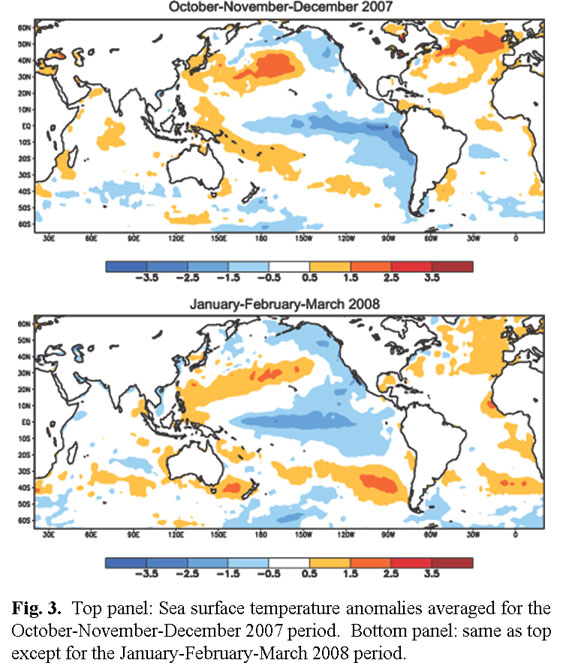
Figure 3

Figure 4

Figure 5

Figure 6

Figure 7

Figure 8

Figure 9

Figure 10

Figure 11

Figure 12
Contact Michelle L'Heureux