MJO Monitoring and Assessment at the Climate Prediction Center
and Initial Impressions of the CFS as an MJO Forecast Tool
Jon Gottschalck, Qin Zhang, Wanqui Wang, Michelle LHeureux, Peitao Peng
Climate Prediction Center , NOAA/NWS/NCEP [Print Version]
1. Introduction
The Madden-Julian Oscillation (MJO) is the leading mode of tropical intraseasonal climate variability and is characterized by organization on a global spatial scale with a period typically ranging from 30-60 days (Madden and Julian, 1971; 1972; 1994, Zhang, 2005). The MJO produces extensive periods of alternating enhanced and suppressed tropical rainfall, modulates tropical cyclone activity and monsoon systems and often impacts the extratropical circulation including over the US (Maloney and Hartmann, 2000a; 2000b; Kousky and Kayano, 1994; Higgins and Shi, 2001; Jones and Carvalho, 2002; Higgins et. al. 2000). The Climate Prediction Center (CPC) is committed to comprehensively monitoring, assessing and predicting the MJO in realtime operations. The CPC is particularly interested in and actively pursuing methods to better understand the MJO and include its potential predictability more effectively into CPC operations -- both to improve the current forecasting capability in the week 2-4 time frame but also in the tropics through weekly hazard assessments. Not only is CPC the official NOAA source for MJO information to the National Weather Service (NWS) regions but also conducts research towards the development of MJO related tools and is responsible for transferring this knowledge and expertise to NWS operations. An important current and especially future area of work is the development, evaluation, and implementation of MJO forecast tools related to the Climate Forecast System (CFS). This article describes current CPC MJO related monitoring and prediction activities and how CPC is currently using CFS within these work areas.
2. Operational Perspective and the MJO
The CPC monitors, assesses and predicts the MJO for three important reasons. First, the MJO alters the pattern of tropical convection substantially and can lead to extended periods of above- and below-average rainfall that can lead to flooding or exacerbate drought conditions. These periods of anomalous rainfall are very important in many regions across the global tropics where rainy seasons are generally short and can have far-reaching socio-economic impacts. The aforementioned effect on tropical cyclone activity and monsoon systems also result in economic consequences when they occur. Second, the MJO substantially modulates the extratropical circulation when it is active and can lead to large-scale transitional changes in the mid-latitudes resulting in extended periods of warmer or colder, wetter or drier conditions and also can lead to extreme events. Knowledge of circulation changes linked to the MJO increase predictability of subseasonal forecasts such as the CPC 6-10 day, 8-14 day, monthly, and hazard forecasts. Third, the MJO can also affect the onset, decay and evolution of the El Nino-Southern Oscillation (ENSO) as some of the most important characteristics of the MJO is its modulation of the low-level wind field that can produce important oceanic surface and sub-surface changes (Kessler and Kleeman, 2000; Zhang and Gottschalck, 2002).
The CPC monitors the MJO and its impacts through numerous web-monitoring products, the routine creation of a weekly MJO update and a global tropics hazards/benefits assessment (Figure 1). The weekly MJO update and global tropics hazards/benefits assessment are produced every Monday and released by 4 PM local time. The assessments incorporate input from all branches of CPC and collaboration from other NOAA centers including the National Hurricane Center (NHC) and the Earth Systems Research Laboratory (ESRL) among other national and international contributors. The purpose of the global tropics hazards/benefits assessment is to 1) assess and forecast changes in the distribution of tropical convection and communicate this information to NWS forecasters, 2) provide advance notice of potential hazards related to climate, weather and hydrological events across the global tropics, 3) serve as an additional resource for sectors of the US economy with international interests (finance, energy, agriculture, water resource management).
The assessment provides forecasts of extensive and persistent enhanced and suppressed tropical rainfall and areas where conditions are favorable or unfavorable for tropical cyclogenesis. The outlook spans the Week 1 - 2 time period. The physical basis for the assessment includes ENSO, the MJO and other coherent subseasonal tropical variability, interactions with the extratropical circulation, numerical weather forecast model guidance, boundary layer forcing (i.e. SST, soil moisture, etc.) and additional statistical forecasting tools.
The assessment is verified for both the precipitation areas and tropical cyclone regions (Figure 2). To date, both categories indicate useful skill and warrant continued development of the product. An emphasis on application of current, under development and planned objective tools is a goal during the next few years to make the assessment more objective in nature.
3. CFS MJO-Related Projects at CPC
The CFS is currently being utilized in intraseasonal monitoring and research in two primary ways at CPC. First, the CFS is being used as part of the MJO realtime monitoring activities in support of the weekly MJO update and global tropics hazards/benefits assessment products. Along these lines, we have applied the Wheeler and Hendon (2004, hereafter WH2004) MJO filtering methodology to realtime operational CFS forecasts. To briefly review, the technique is a spatial filter as opposed to a temporal filter which makes it very attractive to realtime operational applications and is based on a combined Empirical Orthogonal Function (EOF) analysis using Outgoing Longwave Radiation (OLR) and 850-hPa and 200-hPa zonal wind data. In order to pinpoint the MJO signal data pre-filtering is applied and includes removal of the seasonal cycle and ENSO associated variability. An MJO index is defined as the first two principal components (PCs) after projecting data (either observational or model) onto the above EOF structures and these are called realtime MJO mode 1 and 2 (RMM1 and RMM2). An example of the procedure as applied to the ensemble Global Forecast System (GFS), the atmospheric component of CFS, is shown in Figure 3.
The upgrade of operational CFS forecasts from 8-day to 1-day lag during late 2007 has now made it possible to realistically use CFS forecasts in realtime MJO monitoring and prediction applications. The CFS data available are operational forecasts (four members daily) and a lead dependent climatology in order to calculate bias corrected anomalies. The WH2004 methodology is applied and these data are projected onto observed EOFs and realtime CFS RMM1 and RMM2 MJO index values calculated. Figure 4 shows an example phase diagram from a CFS operational forecast along with the verification of the MJO index during the last few years. Anomaly correlation skill of the MJO index remains useful till approximately 7-10 days for operational forecasts ranging from 2005 to February 2008. Utilizing the CFS hindcast datasets, the MJO index was calculated for the historical data record of 1979-2004 and the anomaly correlation skill calculated (Figure 5). The skill here is lower mainly a result of using daily forecasts only. The operational CFS forecasts do include more than one member per day (2 initially and 4 later during 2007).
In addition to the operational realtime CFS MJO index forecast, CFS data is being used as part of an objective MJO forecast tool consolidation activity. Products from this project will be used as objective forecast input for the CPC weekly MJO update and international hazards/benefits assessments. Several tools are available for MJO prediction and include both statistical and dynamical approaches.
Hindcasts were derived from five MJO methods with the goal to choose a wide-spectrum of methods that vary in complexity and diversity. We utilized four statistical models and one dynamical model. These methods include (1) lagged linear regression model, (2) autoregressive model, (3) empirical phase propagation model, (4) constructed analogue model and (5) the CFS. Due to length considerations, the technical details for the models are omitted. The hindcasts are forecasts of the first two PCs based on anomalous data filtered to the MJO time scale (WH2004) with low-frequency variability (i.e., ENSO) removed from both the observational and model datasets. The statistical models were trained on data from the period from 1979-1989 and a set of hindcasts created covering a period from 1990-2004 out to a lead of six pentads or 30 days. No training was necessary for the CFS hindcasts as this is a dynamical model.
A framework for objective consolidation of these forecasts has been developed and weights (to be used for the realtime forecasts) based on the historical data (hindcasts) determined. Two approaches for objective consolidation are used (1) equal weights (CEQ) all methods receive a weight of 0.20, and (2) skill-based weights that account for the independent skill of each method (CRR, co-linearity between methods accounted for). The approach used in (2) is the ridge regression approach. Figure 6 illustrates the weights [as determined by approach (2)] for the five methods as a function of lead and seasonal cycle and indicate when and how much each method contributes to the consolidation. The results show that the constructed analogue method (ANL) contributes the most to the consolidation during the majority of the year. The autoregressive model only contributes to the consolidation during the July-August period and at times longer leads. The CFS only contributes significantly to the consolidation during the September to November time period at generally earlier leads.
Figure 7 shows the anomaly correlation skill for each method and the two consolidation approaches as a function of lead. The results indicate only minor improvement over what can be expected on independent data (after cross-validation) over the best method at any given lead. The results indicate only a 2-4% improvement for pentads 1-3 and 8-18% for pentads 4-6. However, by the later leads, the skill improvement occurs at a time when the skill levels have dropped below what is commonly the cutoff for useful skill (r = 0.5). The CRR approach outperforms CEQ at short leads (pentad 1-3) while CEQ outperforms CRR at longer leads (pentad 4-6). It is believed that the percent improvement of the consolidated ridge regression forecasts is small because the statistical MJO tool approaches offer similar and little independent information so that the consolidation does not substantially improve upon the best method. The CFS dynamical model, although offering useful independent information, has a historical skill level that is quite low and so does not aid the consolidation.
Despite the modest skill shown here by the CFS in prediction of the MJO index, the future of the CFS is bright. The next generation of the CFS is currently under development and evaluation and it offers changes that are expected to improve the skill of forecasts of the MJO index. These changes include 1) the use of more consistent initial conditions, 2) improved spatial resolution, 3) more frequent forecasts (every 30 hours) for a large ensemble, and 4) active MJO research within the Environmental Modeling Center (EMC) in order to improve our physical understanding of not only the MJO but model representations of the MJO. We expect the CFS skill to approach that shown by the Global Ensemble Forecast System after these changes are implemented.
An important collaborative effort underway at CPC is the calculation of realtime MJO index forecasts (WH2004) from not only NCEP models (GFS and CFS) but also with other international operational center model output. The goal is to apply a standard methodology for calculation of the forecast MJO indices, their display, and for their verification. Current participating centers include the National Center for Environmental Prediction (NCEP), European Centre for Medium Range Weather Forecasting (ECMWF), United Kingdom Meteorology Office (UKMET), Canadian Meteorological Center (CMC), Bureau of Meteorology in Australia (BOM), Earth System Research Laboratory (ESRL) and Brazilian Center for Weather Forecasting and Climate Studies (CPTEC). CPC was chosen to lead, host, and disseminate these products.
4. MJO Impacts on CFS SST Prediction
Strong MJO activity developed during November 2007 and lasted through mid-February. It has been hypothesized that the MJO can substantially alter the intensity and timing of the ENSO cycle. Alternating periods of westerly and easterly wind anomalies across the western Pacific during the winter of 2007-2008 strongly affected the CFS SST forecast of La Nina conditions during this period. Figure 8 shows the sensitivity of the SST prediction during different phases of the MJO when the CFS forecast was initialized. Forecasts initialized during the November and early December period resulted in a forecast of cooling conditions for March 2008 while forecasts later during December 2007 and January 2008 resulted in a significantly warmer forecast during March 2008. In fact, the differences in the mean of the CFS SST forecasts during these two periods were large enough for a forecast of a moderate-strong La Nina by themselves (Figure 8).
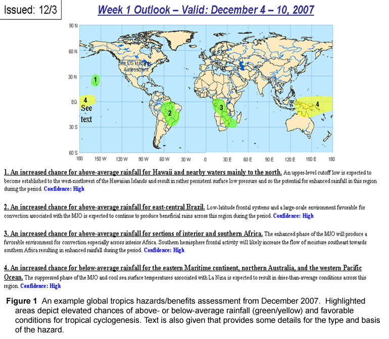
Figure 1

Figure 2

Figure 3

Figure 4
![]()
Figure 5
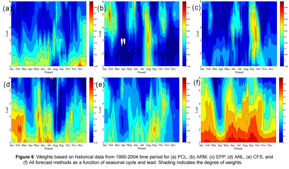
Figure 6
![]()
Figure 7

Figure 8
5. Summary and Discussion
The CPC has a comprehensive MJO monitoring, assessment, and prediction activity as the MJO has large ramifications for a number of CPC operational forecasts and assessments. Operational considerations are important and should be kept in mind when conducting MJO-related research at the Center for Ocean-Land-Atmosphere Studies (COLA). Improved understanding and prediction of intraseasonal variability can improve CPC extended range prediction as the MJO can result in important extratropical transitions leading to extended periods of varying weather regimes. Also, CPC international hazard assessments are heavily influenced by the MJO. The CFS has an encouraging future but currently the skill in prediction of an MJO index is low to modest and useful skill extends out to approximately 7-10 days in this initial analysis and CFS version. The new CFS version is expected to improve the skill.
An important area of research work that could significantly aid CPC forecast operations is an improved understanding of the MJO onset and decay periods (i.e., tropical transitions). Operations are often forced to wait for the MJO to develop or end before forecasts can respond effectively and appropriately. Although the dynamical model MJO index forecasts show some promise for MJO prediction (e.g., November 2007), operational forecasts at CPC can benefit from comprehensive, innovative research targeting MJO initiation and demise periods. For example, what role do extratropical-tropical exchanges play? How important are scale interactions (i.e., diurnal convection, mesoscale regional convection)? Is pre-conditioning of atmospheric moisture the primary player in regenerating the MJO evolution? These questions are quite difficult to answer and most likely will only be answered through a dedicated series of modeling studies. The MJO is a very complex phenomenon and encompasses multiple time and space scales and research in these areas may aid our understanding of the MJO and its operational prediction of US and global impacts.
REFERENCES
Higgins, W., J. Schemm, W. Shi, and A. Leetmaa, 2000: Extreme precipitation events in the western United States related to tropical forcing. J. Climate, 13, 793-820.
Higgins, W and W. Shi, 2001: Intercomparison of the principal modes of interannual and intraseasonal variability of the North American monsoon system. J. Climate, 14, 403-417.
Jones, C. and L. Carvalho, 2002: Active and Break phases in the South American Monsoon System, J. Climate, 15, 905-914.
Kessler, W. and R. Kleeman, 2000: Rectification of the Madden-Julian Oscillation into the ENSO cycle. J. Climate, 13, 3560-3575.
Kousky, V. and M. Kayano, 1994: Principal modes of outgoing longwave radiation and 250-mb circulation for the South American sector. J. Climate, 7,1131-1143.
Madden R. and P. Julian, 1971: Detection of a 40-50 day oscillation in the zonal wind in the tropical Pacific, J. Atmos. Sci., 28, 702-708.
Madden R. and P. Julian, 1972: Description of global-scale circulation cells in the tropics with a 40-50 day period. J. Atmos. Sci., 29, 1109-1123.
Madden R. and P. Julian, 1994: Observations of the 40-50 day tropical oscillation: A review. Mon. Wea. Rev., 112, 814-837.
Maloney E. and D. Hartmann, 2000a: Modulation of eastern North Pacific hurricanes by the Madden-Julian Oscillation, J. Climate, 13,1451-1460.
Maloney E. and D. Hartmann, 2000b: Modulation of hurricane activity in the gulf of Mexico by the Madden-Julian Oscillation. Science, 287, 2002-2004.
Wheeler, M. and H. Hendon, 2004: An All-Season Real-Time Multivariate MJO Index: Development of an Index for Monitoring and Prediction. Mon. Wea. Rev., 132, 1917-1932.
Zhang, C. and J. Gottschalck, 2002: SST anomalies of ENSO and the Madden-Julian Oscillation in the equatorial Pacific. J. Climate, 15, 2429-2445.
Zhang, C. 2005: Madden-Julian Oscillation. Reviews of Geophysics, 43, 1-36
Contact Jon Gottschalck