Review of Recent Changes in Global Ocean Data Assimilation System
David Behringer and Yan Xue
|
Previous studies (Peng
2005) compared the sea surface temperature (SST) produced by the
Global Ocean Data Assimilation System (GODAS) to that by the
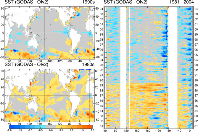
Optimum Interpolation (OI) and found discontinuity
of GODAS SST from 1989 to 1990. The warm bias in the earlier
period was evident. Recently, an error has been identified in
the pre-processing of the
Expendable Bathythermograph (XBT) data
for the years prior to 1990. By
making the correction, a new version of the GODAS data is created and available in the
GODAS web site. The impact of the corrections has
also been examined and illustrated in the following.
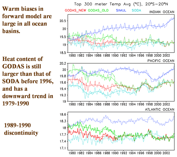
Most of the changes are in 1979-1989 due to corrections of XBT profiles in that period. (Fig. 1) Average reductions of temperature in 1979-1989 are about 0.5-0.6 degree, distributed approximately evenly in depth. (Fig. 2) Average reductions of sea level are 1-2 cm in tropical Indian and Pacific, and 3-4 cm in western tropical Atlantic. (Fig. 3) Average reductions in depth of 20 degree are as large as 18 meter in midlatitude, but only 1-2 meter in the tropics. (Fig. 4) Correlation with tide gauge observations is improved, and it is about 0.7-0.9 in tropical Pacific, and 0.4-0.7 in tropical Indian and Atlantic Oceans. (Fig.5) Although the discontinuity in 1989/1990 is largely removed, there are remaining downward trends in 1979-1990, probably due to the warm biases in forward model. (Fig.6) |
SST Difference from OI data
Old GODAS New GODAS Fig. 1
Fig. 2
Fig. 3 Fig. 4
Fig. 5 Fig. 6 |
|
More challenges are prompted to further improvement. First, the forward model has large warm biases in all ocean basins due to errors in model forcing and physics. Second, the forward model drifts away from initial conditions in Atlantic, probably due to simulation errors of thermohaline circulation. Third, the changes of observation network also contribute to discontinuity and trend in GODAS. To continue improving the GODAS, we are going to assimilate more observations, e.g. the Argo data, and improve the forward model as well as the ocean data assimilation scheme. |
|