 |
The System for
Convection Analysis
and Nowcasting (SCAN) |
|
SEVERE WEATHER EVENT IN PROGRESS: What does
the NWS FORECASTER need to know?Severe thunderstorms
are racing towards Washington D.C. from Pennsylvania. Some are stronger
than others. Some may be producing large hail. Some may be producing tornadoes.
The FORECASTER needs to know QUICKLY
WHICH of the MANY STORMS are the
MOST DANGEROUS and
consider issuing a NWS SEVERE THUNDERSTORM or
TORNADO WARNING. In the MODERNIZED NWS, forecasters
will use the SCAN software on AWIPS
to help them make warning decisions.
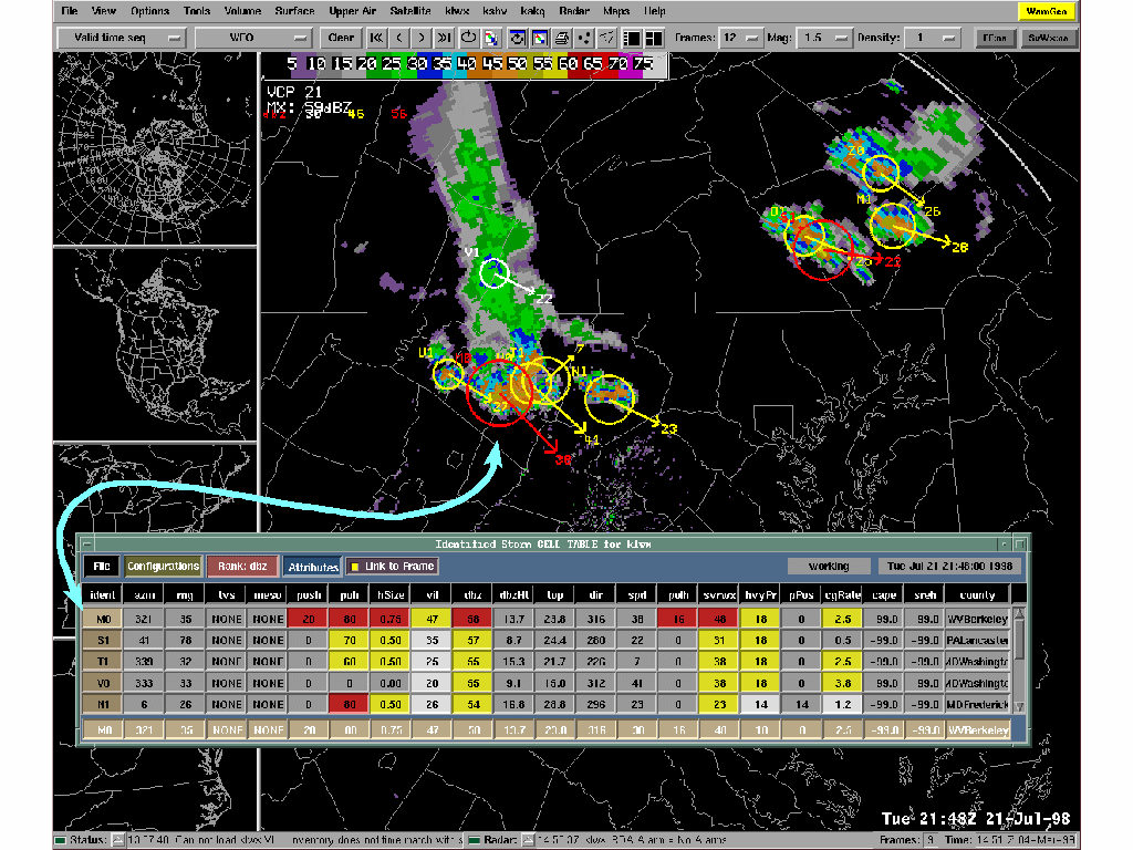
AWIPS 5.0 SCAN DISPLAY for Washington D.C.- Baltimore NWS
FORECAST OFFICE in Sterling, Virginia. The display shows
an ACTUAL SEVERE THUNDERSTORM EVENT that effected
the WASHINGTON D.C. METRO AREA last summer on
July 21, 1998. The display shows NEXRAD radar
echoes with individual thunderstorms indicated by the colored circles.
The STRONGEST STORMS are indicated by the RED
CIRCLES. The individual storms are RANKED
from STRONGEST toWEAKEST
in the THUNDERSTORM TABLE. The STRONGEST
STORM (M0) is placed in the TOP ROW of
the table. The THUNDERSTORM STRENGTH parameters
are shown in the COLUMNS of the table. The values
are colored by severity. Red is most severe. Yellow is less severe. White
is least severe. Five parameters are colored RED
for storm M0, showing why is it the strongest
STORM. In particular, storm
M0 has a HIGH PROBABILITY OF HAIL, 80%.
The THUNDERSTORM TABLE shows the forecaster WHICH STORMS are most dangerous and WHY. The THUNDERSTORM TABLE helps the FORECASTER to make a WISE and QUICK DECISION on whether or not to issue at NWS SEVERE THUNDERSTORM or TORNADO WARNING.
Home
|
National
Weather Service |