![]()
 |
Flash Flood
Monitoring
and Prediction (FFMP) |
|
| FLASH FLOOD MONITORING AND PREDICTION IN AWIPS BUILD 5 AND BEYOND |
| Stephan
B. Smith* M. Thomas Filiaggi |
Jon Roe Mark Glaudemans and Russell Erb |
| Techniques Development
Laboratory National Weather Service Silver Spring, Maryland |
Hydrologic Research
Laboratory National Weather Service Silver Spring, Maryland |
| Michael Churma | Lingyan Xin |
| RSIS Inc. McLean, Virginia |
National Severe
Storms Laboratory Norman, Oklahoma |
1. INTRODUCTION
Flash floods cause more deaths than any other weather-related phenomena. There are many, many different hydro-meteorological paths that can lead to a flash flood. This fact, combined with the short-fused nature of the phenomena, makes flash flood prediction an extremely challenging operational forecast problem. With the completion of its modernization, the National Weather Service (NWS) is in a better position than ever before to address this problem in a comprehensive manner.
The National Quantitative Precipitation Information Plan (Office of Meteorology 1999) presents an extensive road map to improve flash flood monitoring and prediction. To meet these requirements in the Advanced Weather Interactive Processing System (AWIPS) Build 5 time frame (2000-2001), a joint software development team has been formed for the purpose of creating the Flash Flood Monitoring and Prediction (FFMP) hydrometeorological function within the Display-2-Dimensions (D2D; Biere 1998) user environment of AWIPS. This function will be an outgrowth and merging of existing capabilities within the WFO Hydrologic Forecast System (WHFS; Roe et al. 1998) HydroView application and the System for Convection Analysis and Nowcasting (SCAN; Smith et al. 1998a), as well as the Areal Mean Basin Estimated Rainfall algorithm (AMBER; Davis and Jendrowski 1996). The FFMP will provide continuous monitoring of rainfall rate and its comparison to flash flood guidance (FFG) for high resolution stream basins. It will provide both NWS forecasters and external users with automated alerts when a dangerous flood situation may be developing on a given stream or catchment.
By seamlessly integrating the flash flood information within the AWIPS D2D, NWS forecasters will be able to interpret the hydrologic threat within the context of the evolving meteorological situation. For example, a warning forecaster will be able to monitor the initiation and movement of heavy precipitation thunderstorms (as detected in radar, satellite and lightning observations) in and around small-scale stream basins. This information combined with short-term quantitative precipitation estimates (also mapped into stream basins) can increase warning lead times and provide more precise identification of the flash flood-threatened areas (e.g. Davis 1998). This paper describes the basic design of the FFMP.
2. SCAN - A PROTOTYPE FOR NWS DECISION- ASSISTANCE TOOLS
SCAN/FFMP is a major extension of the SCAN functionality introduced in AWIPS Build 4.1 (Smith et al. 1999). SCAN is an integrated suite of applications which detects, analyzes and monitors convection, and generates short-term probabilistic forecast and warning guidance for severe weather and flash floods automatically within AWIPS. In short, SCAN is the nation's automated watchdog for severe weather and flash floods.
The goals of SCAN are:
- To provide forecasters with accurate, timely, and consistent guidance for severe weather and flash floods.
- To develop "smart" computer displays, menus, and graphical user interfaces that optimize the utility of the AWIPS D2D and are coordinated with the other components of the warning decision process.
- To develop multi-sensor databases to support the verification of thunderstorm, severe weather, and flash flood forecasts/warnings.
- To supplement forecaster event monitoring with multi-sensor, automated event monitoring.
- To accelerate the rate of technology transfer from research to operations and external users.
Demonstration of SCAN at the NWS Forecast Office in Sterling, Virginia (Smith et al. 1998b) indicates that operational implementation of SCAN will result in longer lead times on warned events, fewer missed events, increased forecaster situational awareness, reduced forecaster fatigue during warning situations, rapid improvement in implemented techniques, and a well-defined focus for applied research. Version 1.0 of SCAN was delivered to all NWS forecast offices by June 1999. Version 2.0 which include the initial FFMP functionality will become operational in June 2000.
3. SCAN/FFMP in AWIPS Build 5
FFMP is a coordinated set of tools within AWIPS that allows the forecaster to analyze current precipitation observations and short-term forecasts that could lead to flash floods that threaten life and property. The basic FFMP functionality for AWIPS Build 5 is illustrated schematically in Fig. 1. Every delineated hydrologic basin and county in the area of responsibility for a particular NWS forecast office is monitored for heavy precipitation occurring or forecast to occur. Estimated accumulated precipitation is compared (ratio or difference) to River Forecast Center-generated FFG to assess the flash flood threat. Flash flood threat can also be determined directly from excessive rain rates occurring in a given basin or county. Forecasters will have the option to choose the source of precipitation estimates from a selection of radar-only [Digital Precipitation Array (DPA) or the Digital Hybrid Reflectivity Scan (DHR)], gage-only, gage-radar (NEXRAD Stage III analysis), or multi-sensor estimates.
Forecasters will also be able to select a variety of quantitative precipitation forecasts (QPFs) as inputs into FFMP. These include the SCAN 0-1 hr QPF (Kitzmiller 1998), the 1-hr flash flood potential (Fulton and Seo 2000), the SCAN 0-3 hr QPF (Kitzmiller et al. 1999), the LAMP QPF (Charba 1998), as well as a variety of QPFs from the NWS's suite of numerical weather prediction models. All this information will be provided to the user via the D2D in both tabular form (Glaudemans 1999) and geographic displays (see Figure 2). Users will also be able to define a variety of warning thresholds that FFMP will automatically check and alert the forecasters to if exceeded. Offices will be able to monitor flash flood threats on very small (as small as 2 mi2) stream basins using the 1o x 1 km DHR (e.g. AMBER; Davis and Jendrowski 1996) and fine resolution basin boundary information.
4. THE FUTURE
4.1 Service Impacts:
The implementation of FFMP will set the stage for major improvements in specificity, accuracy, and timeliness of official NWS flash flood warnings. Forecasters will be able to refer to particular streams and watersheds under the threat of flash flood within the body of traditional text warnings. In addition, high resolution graphical warning products issued in common Geographic Information Systems (GISs) formats will allow emergency managers and others to integrate directly the flood warning information within their own custom GIS decision-assistance software packages.
4.2 Enhancements:
FFMP in AWIPS Build 5 will lay a firm foundation on which to build further enhancements to operational flash flood forecasting. These include, but are not limited to, the incorporation of improved FFG, remotely-sensed land-use information and soil moisture estimates, ensemble streamflow prediction, and distributed hydrological modeling (e.g. Vieux et al. 1998). Through SCAN/FFMP, these scientific advances will provide a pathway to the next generation of hydrologic flash flood services for the Nation.
ACKNOWLEDGMENTS
The authors would like to thank Jeff Zimmerman, Tom Graziano, and Roger Pierce for their work in developing the requirements for SCAN/FFMP. We are gratefull to Bob Davis and Paul Jendrowski for the development and operational demonstration of AMBER as well as guidance in the design of the small-basin monitoring function of FFMP.
REFERENCES
Biere, M., 1998: The WFO-Advanced Two-Dimensional display software design. Preprints 14th International Conf. on Interactive Information and Processing Systems, Phoenix, Amer. Meteor. Soc., 376-379.
Charba, J. P., 1998: The LAMP QPF Products. Part I: Model Development. Wea. Forecasting, 13, 934-965.
Davis, R. D., and P. Jendrowski, 1996: The operational Areal Mean Basin Estimated Rainfall (AMBER) module. Preprints 165h Conf. on Weather Analysis and Forecasting, Norfolk, Amer. Meteor. Soc., 332-335.
_____, 1998: Detecting the time duration of rainfall: A controlling factor of flash flood intensity. Preprints Special Symposium on Hydrology, Phoenix, Amer. Meteor. Soc., 258-263.
Fulton, R. A., D.-J Seo, 2000: A prototype operational 0-1 hour radar-based flash flood potential algorithm. Preprints 15th Conf. on Hydrology, Long Beach, Amer. Meteor. Soc., (this volume).
Glaudemans, M., 1999: Monitoring of Short-Fused Flood Events by the National Weather Service Hydrologic Forecast System. Preprints 15th Conf. on Interactive Information and Processing Systems, Dallas, Amer. Meteor. Soc., 525-528.
Kitzmiller, D. H., 1998: The AWIPS 0-1 hour rainfall forecast algorithm. Preprints 15th International Conf. on Interactive Information and Processing Systems, Dallas, Amer. Meteor. Soc., 175-178.
_____., M. R. Lilly, and S. D. Vibert, 1999: Probabilistic 0-3 hour rainfall forecasts from an extrapolative-statistical technique utilizing radar, satellite, and lightning observations. Preprints 29th Conf. on Radar Meteorology, Montreal, Amer. Meteor. Soc., 876-879.
Office of Meteorology, 1999: The modernized end-to-end forecast process for quantitative precipitation information: Hydrometeorological requirements, scientific issues, and service concepts. NOAA, U.S. Dept. of Commerce, 187 pp.
Roe, J., M. Glaudemans, C. Gobs, P. Taylor, and J. Zimmerman, 1998: Implementation of modernized hydrologic operations and services in the National Weather Service: Overview and status. Preprints Special Symposium on Hydrology, Phoenix, Amer. Meteor. Soc., J25-J30.
Smith, S., T. Graziano, R. Lane, W. Alexander. M. Eilts, J.T. Johnson, J. Wilson, R. Roberts, D. Burgess, D. Kitzmiller, R. Saffle, R. Elvander, S. Zubrick, J. Schaefer, S. Weiss, and D. Imy, 1998a: The System for Convection Analysis and Nowcasting (SCAN). Preprints 16th Conf. on Weather Analysis and Forecasting, 14th International Conf. on Interactive Information and Processing Systems, Phoenix, Amer. Meteor. Soc., J22-J24.
_____, J. T. Johnson, R. D. Roberts, S. M. Zubrick, and S. J. Weiss, 1998b: The System for Convection Analysis and Nowcasting (SCAN) 1997-1998 Field Test. Preprints 19th Conf. on Severe Local Storms, Minneapolis, Amer. Meteor. Soc., 790-793.
_____, S. K. Goel, M. T. Filiaggi, M. E. Churma, and L.. Xin, 1999: Overview and status of the AWIPS System for Convection Analysis and Nowcasting - SCAN. Preprints 14thInternational Conf. on Interactive Information and Processing Systems, Dallas, Amer. Meteor. Soc., 326-329.
Vieux, B. E., A. T. Jones, M. D. Eilts, and J. T. Johnson: Planned integration of a distributed hydrological model with the warning decision support system to assist in flash flood warning decisions. Preprints Special Symposium on Hydrology, Phoenix, Amer. Meteor. Soc., 291-293.
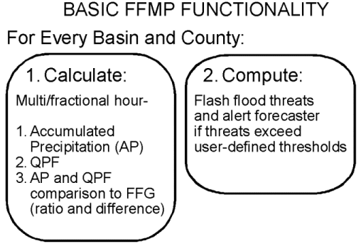 |
| Figure 1. Basic FFMP Functionality for AWIPS Build 5. |
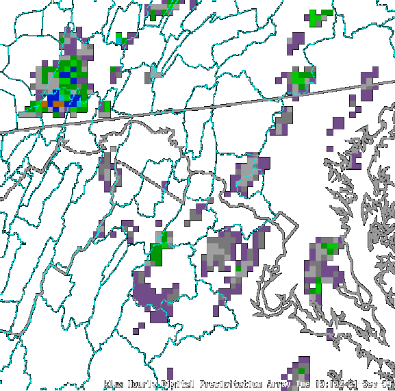 |
| Figure 2. AWIPS D2D display showing hourly accumulated precipitation from DPA with states (thick lines) and river basins (thin lines) as a map background over Washington D.C. area. |
__________________________________________
*Corresponding author address: Dr. Stephan B. Smith, TDL/NWS, SSMC2, 1325 East-West Highway, Silver Spring, MD 20910. e-mail: Stephan.Smith@noaa.gov
DAB
| MDL | NWS
| NOAA
| DOC
SCAN | Fog Monitor | FSI | SAFESEAS |
GUARDIAN | SNOW
|
National
Weather Service |
Privacy Policy |